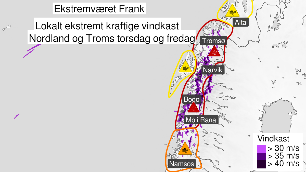
Warning from MET Norway for Nord-Helgeland, Salten, Ofoten, Sør-Troms and Nord-Troms
4
Extremely strong wind gusts, red level (MET)
Published:
Valid:
from 21.01.2021 13:00
to 22.01.2021 13:00
Warning
Wind gusts
-
Sender: MET Norway
-
Danger ongoing: Thursday, January 21, 2021, kl.1:00 PM
-
Danger decrease: Friday, January 22, 2021, kl. 1:00 PM
-
Certainty: Likely > 50%
Name
Frank
Consequence
It is dangerous to be outdoors, and unusually large damage to buildings, infrastructure, forests and power supplies is expected. Expect cancelled departures for ferry, plane, or other transport. Bridges may be closed. Ceiling tiles blow off houses and buildings. Allow a lot of extra time for transportation and driving, even for short journeys. The power supply locally will be significantly affected. Many roads may be closed due to trees or other objects. Blowing snow causes reduced visibility and possibly convoys and/or closed roads. The strong wind may cause locally high waves in fjords and lakes.
Advice
Follow the advice of emergency authorities. If you MUST drive, follow the advice from the Norwegian Public Roads Administration and check road reports (175.no). Follow advice and check status from transport operators. Prepare your home for a potentially long power outage. The need for emergency preparedness shall be assessed continuously by emergency response actors. In advance consider measures to limit damage.
Description
From Thursday afternoon east and southeasterly storm with extreme gust locally with 35-50 m/s. There are expected strongest winds from Thursday afternoon until Friday afternoon. There will be large variations in wind speed. Some places may have calm conditions while other places experience extreme wind gusts. In addition the temperature at exposed places is expected to be in -the range of 10 to -15 degrees. The combination storm and low temperatures could cause challenges for power delivery, there is potenial for frost bite and risk of moderate to severe icing on ships.